
‘Hurricane Hunters’ footage takes you inside the ferocity of Hurricane Lee, monster gears up for a strength surge
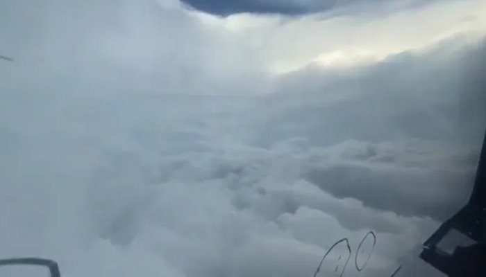
The eye of Hurricane Lee, the monstrous Category 5 storm, was captured on video by storm chasers who flew into it on Thursday.
The 20-second footage shows the storm’s fury as it produced lightning flashes and winds of 165 mph. The footage was captured by the 53rd Weather Reconnaissance Squadron of the Air Force Reserve, famously known as the “Hurricane Hunters.”
They departed from St. Croix, US Virgin Islands, and entered the eye of Lee as it was rapidly intensifying from a Category 1 to a Category 5 hurricane.
By early Saturday, Lee had weakened to a Category 3 storm, but it is expected to regain strength over the weekend.
However, the storm’s path and impact on the East Coast are still uncertain, as forecasters said it was too early to tell if or where Lee would make landfall.
“It will eventually begin to re-strengthen into probably a Category 4 storm based on the Hurricane Center’s current forecast,” Fox Weather meteorologist Christopher Tate quoted to The New York Post.
But he also added some good news saying, “That return to Category 4 strength will be relatively short-lived because as it begins its turn north, it’s going to begin to weaken as it encounters cooler waters.”
Lee was moving north and west at about 12 miles per hour in the Caribbean early Saturday.
According to the National Hurricane Center, it may impact Puerto Rico, Hispaniola, Turks and Caicos, the Bahamas, and Bermuda on Sunday.
Hurricane Lee is poised to generate turbulent ocean conditions along the New York/New Jersey coastline for a minimum of the next week.
A factor contributing to the challenge of forecasting its coastal impact lies in its anticipated deceleration upon encountering cooler waters.
Many questions remain unanswered about the storm’s path, but right now it is not expected to make landfall in the U.S.
“One thing we are sure of, anytime you have a hurricane of this strength, you’re going to see strong rip currents, higher waves, beach erosion — probably pretty much anywhere on the East Coast, especially north of about Charleston, South Carolina clear up all the way to the Canadian Maritimes,” Tate explained.