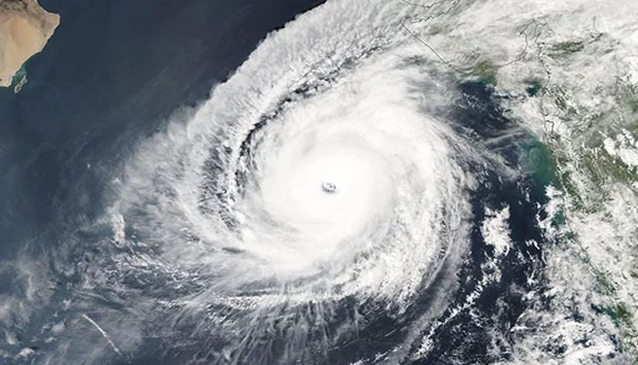
Cyclone Biparjoy to intensify into very severe storm in 24 hours; Maharashtra, Karnataka, Goa to be affected, says IMD
Cyclone ‘Biparjoy,’ which was last recorded over the east-central and southeast Arabian Sea, is expected to shift northwards and intensify into a severe cyclonic storm.
Within the next 24 hours, the Indian Meteorological Department (IMD) said on Wednesday. In its latest bulletin issued at 5:30 am on Wednesday, the IMD warned of consequent harsh weather and sea conditions, with wind speeds potentially reaching 135-145 kmph, and gusting up to 160 kmph over the next three to four days. The IMD has also advised fishermen to avoid venturing into the sea.
Cyclonic storm “Biparjoy” over east-central and adjoining southeast Arabian Sea at 2330 IST of 6 June near lat 12.5°N and lon 66.0°E, about 900km WSW of Goa. Likely to move nearly northwards and intensify into SCS during the next 6 hours: IMD pic.twitter.com/WrEOWjY3co — ANI (@ANI) June 6, 2023
As of 2:30 am on June 7, the cyclonic storm remained stationary for three hours, approximately 900 km west-southwest of Goa, 1020 km southwest of Mumbai, 1090 km south-southwest of Porbandar, and 1380 km south of Karachi.
Coastal areas of Lakshadweep, Karnataka, Goa, and Maharashtra likely to face impact
The impact of Cyclone Biparjoy is anticipated to be felt in several southwestern states. The IMD has issued a wind warning for the next five days in these regions.
On June 7, gale winds with speeds of 80-90 kmph, gusting up to 100 kmph, are likely to prevail over the east-central Arabian Sea and adjoining areas of the west-central and southeast Arabian Sea.
By evening, these winds may intensify to 95-105 kmph, gusting up to 115 kmph in the same area. Adjoining areas of the west-central and south Arabian Sea, and the coasts of north Kerala, Karnataka, and Goa are therefore likely to be most impacted by the storm.
On June 8, the wind speeds are expected to increase further, reaching 115-125 kmph, gusting up to 140 kmph from the evening. Areas along the Karnataka, Goa, and Maharashtra coasts will experience strong winds.
By June 9, wind speeds may escalate to 135-145 kmph, gusting up to 160 kmph from the evening, affecting the adjoining areas of the South Arabian Sea, Karnataka, and the Goa-Maharashtra coasts.
On June 10, gale winds with speeds of 145-155 kmph, gusting up to 170 kmph, are predicted over the central Arabian Sea. The adjoining areas of the south Arabian Sea, as well as the coasts of north Karnataka, Goa, and Maharashtra, will also be impacted.
Warnings issued for fishermen
To ensure safety, the IMD has issued a warning for fishermen to refrain from venturing into the sea until June 10. Fishermen currently at sea are advised to return to the coast.
In the directions issued on IMD’s official website, it is advised that fishermen should avoid venturing into the central and adjoining areas of the south Arabian Sea from June 7 to 9, and the central and adjoining areas of the north and south Arabian Sea on June 10.
Fishermen along and off the Kerala-Karnataka coasts, as well as the Lakshadweep-Maldives areas should remain cautious on June 6 and 7. While the ones along and off the Konkan-Goa-Maharashtra coasts should remain cautious from June 8 to June 10, the IMD stated.

