
The devastating flash floods in Sikkim following a sudden glacial lake burst on Wednesday has claimed several lives, causing widespread damage as roads, bridges, and homes were washed away.
The Teesta River took a furious form, and part of the state’s biggest hydropower project, Sikkim Urja, was washed away, exacerbating the situation. Rescue operations remain a major challenge due to mudslides, washed-out roads, and damage to communication systems.
WHAT LED TO THE FLASH FLOOD
The disaster unfolded with a cloudburst over Lhonak Lake in northwest Sikkim early on Wednesday, after 12 am.
The Urja dam, located 5,000 feet above sea level at Chungthang, and a 200-meter-long bridge connecting the powerhouse were washed away. The entire powerhouse got submerged in the floods. Expert assessments revealed that the water level in the Teesta was below the danger mark before the dam burst.
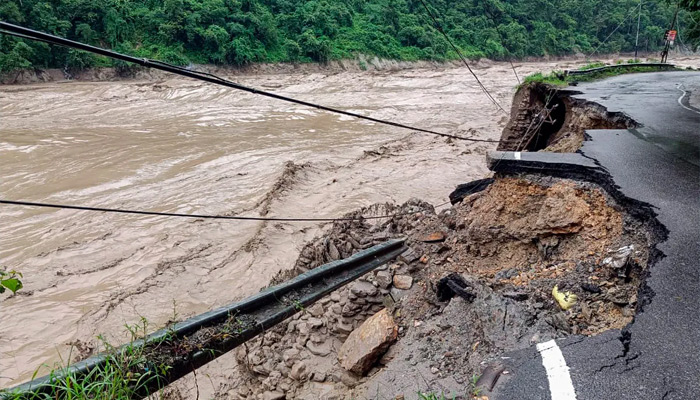
The downstream of Teesta after the dam saw massive destruction. Several houses and buildings were damaged, roads washed away, and at least 11 bridges collapsed.
Areas like Mangan, Dikchu, Singtam, Rangpo, Chungthang, and Bardang were hit hard.
Satellite images of the glacial lake showed that nearly 65 per cent of its water gushed into the Teesta River.
WHY THE LAKE BREACHED
The primary trigger was the cloudburst, during which more than 10 centimetres of rainfall occurrs within 10 square kilometres within an hour.
Along with that, scientists also point out the possibility of an avalanche. The banks of the lake probably burst after chunks of ice fell into the water, creating a powerful wake in the water.
Highlighting the ice patches floating on the lake surface, as shown in satellite images, Jakob F Steiner, a senior scientist said, “It could be that a chunk of either ice or unstable slopes has detached and dropped into the lake water.” This can create shock waves across the water surface that would be enough to topple the lake’s dam, he said.
WARNINGS IGNORED
The flash flood due to the glacial lake burst is deemed dangerous unlike those triggered by excessive rainfall. The powerful and enormous volume of water, all at once, carries debris and large particles downstream, causing severe damage. The speed of the water discharge due to the glacier lake burst can go up to 90–95 kilometres per hour.
Notably, Lhonak Lake was one of the fastest-expanding lakes in the Sikkim Himalaya region. Several studies have pointed out the rapidly growing nature of the lake due to the melting of the adjacent North Lhonak and main Lhonak glaciers.
A study by the National Remote Sensing Centre and the Indian Space Research Organisation (Isro) in 2013 identified South Lhonak Lake, which is a moraine-dammed lake with a capacity to store a significant amount of water, as potentially dangerous with a high outburst probability.
Similar other studies also warned the same on multiple occasions, especially linked to the increase in glacier melting and avalanches due to climate change and global warming. The very nature of moraine dams is unstable, as the water is blocked by ice packs and loose rocks.
Between 1962 and 2008, the Lhonak glacier receded by 2 km and by another 400 meters between 2008 and 2019.
WHAT HAPPENED AFTER THE LAKE BURST
Nearly 65 per cent of the water from the Lhonak lake drained after the flooding. Satellite images released by the Indian Space Research Organisation (Isro) and the National Remote Sensing Centre showed that the area of South Lhonak Lake was drastically reduced to just 60.3 hectares on October 4, from 167.4 hectares on September 28.
“It is observed that the lake burst, and about 105 hectares of the area has been drained out, which might have created a flash flood downstream,” noted Isro.
Considering the significant increase in the lake area, the state government in 2016 installed high-density pipes to drain the water.
A camera to monitor Lhonak Lake’s level and weather instruments were installed last month. According to scientists quoted by Reuters, a fully operational warning system could have given people more time to evacuate.
Lhonak Lake is not an isolated lake. According to recent research, more than 200 such lakes now pose a very high hazard to Himalayan communities in India and neighbouring countries.